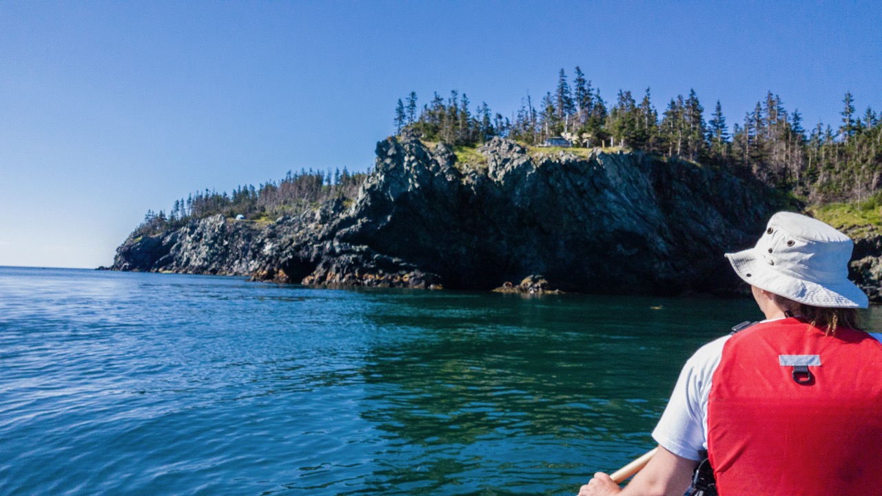
Grand Manan Island, New Brunswick
This is a a place you should look into going.
Grap yourself a beverage and enjoy a visit to Grand Manan New Brunswick!
https://jedijeffi.wordpress.com
Attach new picture


Share your experiences about trips you did, ask for info about trips you dream about...
This is a a place you should look into going.
Grap yourself a beverage and enjoy a visit to Grand Manan New Brunswick!
https://jedijeffi.wordpress.com
Greetings, all.
A group I paddle with is doing the Ashuapmushuan in Quebec this year. They have "maps", but I'm used to going from good old green-and-white-and-blue topos.
Does anyone have the coordinates for this - or the map-names of the respective ones?
Thanks muchly.
John.
Happy 150th Birthday Canada! Yesterday you threw all that the restrained Canadian Heritage Humber River has left of it's forces at us.
On Sunday the 2nd of April we were lucky enough to have ideal conditions for our descent from Bolton to Kleinburg, Ontario. It rained heavily through Friday, yielding peak water levels, and then it was sunny with a high of about 13C.
There was an excellent turnout, including 9 canoes, 1 kayak, 17 paddlers, and a bored golden retriever.
There are two gauges for the river but neither has proven to be very useful. This TRCA link for the McFall Dam gauge (C) shows only a stage measurement. Because there are 3 fixed weirs at this location, it never reads anything other than altitude at the water line. See if it reads 213 meters. If this level ever increases substantially, it is time to break out the sandbags as there is some serious flooding already going on in the GTA.
This one for station 02HC025, managed by Environment Canada, includes a discharge number. Unfortunately it stopped working just before our outing.
So I will describe: at the diversion project in Bolton, just downstream of the McFall dam, there was a substantial flow over the bypass weirs, enough to float boats such that it would have been dangerous to lift over them in fast water. One solo canoe ran the second weir and everyone else portaged the entire length. This included the spectacle of us carrying canoes across Humber Lea Road, something that lifelong residents have likely never seen before.
We blamed it on the ice storm at Christmas 2013. There were many more downed trees and log jams in the river than recalled from previous years, and eventually this contributed to the passage taking 2 hours longer than planned for. Eight hours instead of six for the 28 kilometers downstream to Humber Bridge Trail at Kleinburg. There were 2 or maybe 3 places that required actually getting out and lifting the boats onto, or over a low log. In one spot some of us did actually drag the boat over the shoreline a short distance. Otherwise there were at least a dozen occasions of canoe limbo under low fliers as well as numerous S-turns required to navigate around successive sweepers in cross currents. She who forces me to paddle my non-dominant side, and I, substantially improved on our back-ferry.
Four paddlers took the plunge eventually, with one classic sweeper storyline. With the solo canoe turned sideways while the paddler attempted to get up on top of the log, he stepped onto something not entirely stable. The upstream gunnel tilted and filled the canoe with water, it was then swept under the log upside-down and had to be pulled out the other side. It took nearly two hours to escape the Bolton proper. Later on there were much longer uninterrupted stretches with successive swifts where we made up time substantially. Especially towards the end of the day there were chains of 10-15 consecutive swifts with short breaks in between, and nothing more substantial than fast moving water with obvious routes around shallow eddies.
Deep inside the conservation lands we encountered full-blown highway construction signage warning of the approaching pipeline, which turned out to be a flexible hose of some sort. There were several instances of this; a hose emerging out of the river and ending at a cooler box presumably holding the instrumentation. This was accompanied by impressive lengths of survey stakes and flagging tape marking out what, we have no idea.
It was clear that everyone was worn down by the end of the day, having gained valuable experience that will make the Upper Credit look like a breeze next weekend.
I am heading into Woodland Caribou Provincial Park this spring for a solo. My planned route takes me from Artery Lake through the center of the park to Indian House Lake. Has anyone done this trip?
Our group of whitewater trippers from Wisconsin (U.S.) have done the Spanish (Biscotaising to Lake Agnew) and the Missinaibi ( Peterbell to Mattice) in Ontario and are looking for another challenge for 2017. We run with tandem canoes and are quite experienced, also having done the Dumoine and Noire Rivers in Quebec. Any suggestions?
CreditRiver March 26th, 2016
Links died
SATURDAY March 26, 2016 - 1:00 PM START
Shape
Start: Below broken dam above Barbertown Road. Follow Culham trail north from the
Portico Community Church. Follow signs.
Finish: The footbridge in Erindale Park (north side of Dundas St. West, first entrance just
east of Mississauga Rd.) Awards handed out at this location.
Course: 10 km of Class I - II rapids.
Classes: K-1 Long, K-1 Jr Long, K-1 Women, K-1 Rec., K-1 Jr , Masters, C-1 Open,
C-2 Open, Adult & Child (Long = wildwater racing kayaks)
Cost: $15.00 per person;
Shape
Registration: Saturday 10am - Noon at Culham Trail Parkette, Barbertown Road.
Info: Linda Reiche 905-793-9970 x 223 (work) or 905-862-3157 (home)
e-mail : linda.reiche@hubergroup.com
Harold Van Winssen 613-848-6209
e-mail: hvanwinssen@tmlegal.ca
Call Harold at 905-848-6209 on Friday March 25th for Credit “go” or Credit “no” or Credit “alternate start” information.
Humber River April 2nd 2016
We are pleased to be involved in sponsoring the 39th Annual Humber River Downriver Race. Please note this race involves whitewater up to grade 2 and cold, rocky and possibly dangerous conditions.
Start
The start is anticipated to be Saturday 1 pm April 2, 2016 under the Islington Bridge at the bottom of Rowntree Mill Park. Parking at Irene Risk Centre. Ice has required us to get anew date.
Directions
Irene Rick Centre is north side of Finch at Islington Avenue.
Finish
The finish is at Dee Avenue, just south of Highway 401, west off of Weston Road.
Length
The length of the race is approximately 11 kilometres.
Classes
The classes are as follows:
Open Canoe (C-2) Maximum length 17 ft.
Open Canoe (C-2 - Adult and
Child)The child must be under 16. Maximum length - 16 ft.
Open Canoe Singles (C-1)Maximum length of canoe - 16 ft.
Other Open Canoe Classes(Womens, Mixed, Masters
as numbers permit)
Kayaks Slalom/Recreational(Womens, Mens, Jr. Women & Jr. Men as numbers permit)
Kayaks - Wildwater/DownriverWomens, Mens, Jr. Men & Jr. Women as numbers permit)
There must be a minimum of three entries per class.
Registration
Registration is $15.00 per person.
Registration
Alternate Contact
Harold Van WinssenEd Winacott
22 Georgian CourtBox 136, R. R. #2
Belleville, OntarioPefferlaw, Ontario
K8N 5R3L0E 1N0
Ph. (613)966-2620
Cell 613-848-6209Ph. (705) 437-2425
Fax (613) 966-2866
email - hvw@tmlegal.caemail - barnmusic73@hotmail.com
Moira River April 17th 2016
1 PM
Registration is from 11 am to 12:30 at the start
Classes:
Open Canoe; Single and tandem ( we will run additional classes if there is demand)
Recreational Kayaks; Men, women, junior men and women, cadet men and women
Wildwater Kayaks and Canoes: Men, women, junior and cadet, C-1 and C-2
A minimum of three boats for a class
Entries; $15 per person
Mail;
Harold Van Winssen
22 Georgian Court
Belleville, Ont
K8N 5R3
Email; hvw@tmlegal.ca
613-966-2620
613-848-6209
Water:
Generally Grade 2 with some easy grade 3 in high water
Start/Finish
The start is at the Chisholm Dam. Take Hwy #37 North form the #401 at Belleville or south from #7. In Roslin which is about 20 kilometers from the 401 and 30 k from #7 turn east on Shannonville Road and follow it about 2 km until it crosses the river at the start. The finish is at Latta on the west side just above the dam off Hwy #37
Jeff
Merry Christmas, and I am sorry for this very late urgent request I just received.
For those who don't don't know me I have been paddling for almost 50 years and am a former Sprint and White water National Champion. (70's and early 80's)
I am presently the Conservation chair for the Wilderness canoe Assoc. but still an active paddler.
This club could really use a written show of support on the major benefits of community based organizations.
Especially the more remote communities like blind river.
Thanks in advance for any support and please feel free to pass the information on.
Jeff McColl
Link to issue
Just got this message:
Hi all,
I don’t know whether you have heard, but the Algoma Paddlers have trouble with Town Council in Blind River and they could use our IMMEDIATE support.
Without consultation and with two weeks notice, they are being thrown out of the building where all their equipment is stored so that the Town can store two trucks. The building belongs to the Town; however, it was in bad shape before the Algoma Paddlers fixed it up at their own expense (reinforcing and fixing walls and doors, adding a sump pump, painting, etc.). They have to be out by December 24th and have no where else to store all their equipment! By the way, there is room for the trucks and the paddling equipment....but that wasn’t offered as an option by the Town.
I’ve written the attached letter and perhaps you would consider adding your voice in support before Monday evening’s Council meeting. Spread the word....
to provide support to email sue.jensen@blindriver.ca. She is Mayor
Sample letter (if you are not a member of the canoe club, tweek it)
December 12, 2015
Mayor and Council of the Town of Blind River
11 Hudson Street, P.O. Box 640
Blind River, ON
P0R 1B0
OPEN LETTER TO MAYOR AND COUNCIL – WITHOUT PREJUDICE
We are writing to express our dismay at the news that your Council has passed a resolution asking the Algoma Paddlers, with no consultation and at very short notice, to remove themselves and their equipment from a building which they refurbished at no expense to the Town.
Over the past two years, this group of your citizens have donated their time and materials to increase the value of this building to house three historically-significant Montreal canoes, plus trailers, kayaks, canoes, paddle boards etc.; more than $150,000 worth of equipment that supports Algoma Paddlers programming in your area.
The Algoma Paddlers (AP) has put Blind River on the map in the paddling community. They are well-associated with commercial outfitters and other paddling clubs across Ontario. This club has strong ties to the Barrie Canoe & Kayak Club. My husband and I are members of both Clubs. Because the Algoma Paddlers make their home in Blind River, paddlers like us visit, provision our trips in your stores, stay at your motels and support your restaurants. We come to participate in trips, voyageur re-enactments, community paddling events and to take instruction from provincially-qualified instructors.
The AP has built partnerships with First Nations communities on the North Shore by offering instruction to youth and re-enacting traditional journeys. This creates an opportunity for the Town to highlight the history of this beautiful area, and to build collaboration and partnerships with indigenous neighbours in keeping with provincial direction.
Your website says: Established in 1906, Blind River is an outdoor recreation hotspot on Lake Huron's North Channel at the mouth of the Blind River and the Mighty Mississauga River. Explore the many opportunities for fishing, hunting, boating and water sports, or the full range of winter and summer festivals that have put Blind River on the map as one of the "Top 50 Ontario Festivals". Supporting this club with a water-front facility, a place to store their equipment and run their programming (e.g., see Town website for summer youth camp opportunities) can only benefit the Town of Blind River. Their presence is an opportunity for you.
It is our hope that you will reconsider your decision to kick them out on Christmas Eve and take a more thoughtful, farsighted and collaborative approach. We understand there is enough room in this building for both AP equipment and Town equipment. Wouldn’t that be a more cooperative approach to protecting community assets?
Respectfully,
Topo Maps: The WCA connections you make are worth the price of admission.
Emmy Hendrickx, our membership secretary received an inquiry from Sandy Gage about some old topo maps. Sandy and a friend Jeremy Baumbach wanted to see if there is still life in them for another member to use. Emmy passed the email onto me and I met with Sandy for a coffee and conversation on our many canoe trips. Sandy and Jeremy passed on to me several topo maps to donate to any member of the WCA who is thinking of their next adventure down these rivers.
Some of the maps have trip information marked on them. Sandy Gage and Jeremy Baumbach might be able to add further information if asked too.
I have the following topo maps to donate if you have an adventure planned.
Spanish River
41 P/5 Westree, Sudbury, Ontario 1:50
41 P/4 Low Water lake, 1:50
41 I/13 Pogamasing, 1:50
41 I/12 Cartier, 1:50
41 I/15 Espanola, 1:50
French
41 H/15 Key Harbour, 1:50
41 I/2 Delamere, 1:50
Moose River
42 P/2 Bushy Island, 1:50
42 I/14 Moose River, 1:50
Missinaibi River & Mattagami River
42 I/12 Pickett Creek, 1:50
42 J/8 Wawa lakes, 1:50
Abitibi River & Mattagami River
42 I/5 Ranoke, 1:50
42 H/13 Fraserdale, 1:50
Mattagami River
42 J/1 Smoky Falls, 1:50
42 G/16 Bennet Lake, 1:50
42 H/12 Abimatinu River, 1:50 (Ground Hog River)
42 H/5 Smooth Rock Falls (Ground Hog River)
Canada Department of Mines and Technical Surveys
Sheet 31 E/N.E. Algonquin, Ontario, 1:126,720
Department of Lands and Forests
Map showing Exploration Routes through the Huron and Ottawa Territory between years 1615-1854
Topo
Algonquin Park
31 E/16E Lake Lavieille, 1:50 (Petawawa River)
Topo
105-O Niddery Lake (Yukon Territory & NWT) Hess River, 1:250
Thank you Sandy and Jeremy for donating the maps to future adventures in the WCA.
May be other members can post a list of maps they have to pass on to the WCA website.
I can bring them to the WCA wine and cheese event or hand them off somewhere else.
P.S.
I, Gary James, have had the Abitibi, Mattagami and Ground Hog River on my “To Do List” for a while. If anyone is planning or what’s to plan a trip on one or more of these rivers let me know.
gary.james@sympatico.ca
Really, really long post,
very pic heavy.
So here is a link to the report on myccr
http://www.myccr.com/phpbbforum/viewtopic.php?f=108&t=44451
Jeff