Discussion about Trips, Events, etc.

Description

Share your experiences about trips you did, ask for info about trips you dream about...

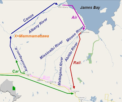
Lower Albany - looking for more information, maps, shuttles, planes

I am looking for informatiuon re the Lower Albany.

the only  info i found sofar is a trip report from  1983

So far i learned to drive to Hearst, somehow do a shuttle/ bus ride to Cochrane.but don't feel comfortable leaving my gear just sitting around is not really an option in 2022
 

then over the kamikami river to Mammamattawa to the lower albany  to Fort albany

how is the lower Albany, flat, white water? 

i read that the airport in Fort Albany  is before you hit the delta of the Albany river - which could be confusiing

then I need info how to get from Fort Albany, to Moosomee, back to Cochrane or Hearst.


Attach new picture

Looking for river maps for Natla River

I am planning for a trip on the Natla River to the confluence with the Keele. I have searched the Map Library on this site but haven’t found maps for this river.

Does anyone have maps of river features (rapids, canyons, creek junctions, hazards, log jams etc.) or a downloadable .kmz file that could be opened in Google Earth or uploaded into Garmin in reach.

Your help would be appreciated.

George Burns

New Hazelton

BC

Nith- April 5, 2025

If the conditions are right I am going to run the Nith from Canning to Paris on Saturday April 5. I Will keep an eye on weather and water levels to ensure there will be flow before posting the trip a week or two before. Hoping for more rain.

The Route Less Paddled

Just reading "The Route Less Paddled: A 4,400km Expedition from Minnesota to the Arctic Ocean" in the latest WCA email. Reminded me of a similar story I read years ago.

In 1930, Eric Sevareid was 17 years old, had just graduated from high school, and was looking for some adventure. He and a friend looked at some maps and decided they could paddle from Minnesota to York Factory, on Hudson Bay. "I hadn't the faintest conception of what we were really letting ourselves in for."

The pair knew next to nothing about canoes, had unreliable maps, and people told them repeatedly to give up. But they made it, paddling some 2200 miles (3500 km).

Sevareid went on to become a CBS news reporter, covering stories around the world, including wars. When he looked back on that canoe trip, he said, "I would follow shock troops across a hundred invasion beaches before I would repeat that youthful experience of the rivers. I simply could not do it again."

The story is in his book "Not So Wild a Dream." Long out of print, but still available online.

Lower Drowning River

Looking for info on tripping down the Drowning River below the juncture with the Wababimiga River. Is there any access points to enter or exit the lower Drowning? Do you have to go all the way to the mouth at the Kenogavi before you can get an air flite out? Any info would be appreciated. Thank you

Bonaventure 2022

I'm working on organising a trip to paddle the Bonaventure River in June 2022.

I understand that there were some major floods in Dec 2020 that made the logjams and sweepers a lot worse than than they used to be. Does anybody have any updated information on the state of the river? Has anybody paddled it in 2021? If so, I'd love to hear from you.

I would also be open to have a few additional people join the trip; contact me if you're interested (please note this is an advanced trip). I'll be posting an outing description in the next few weeks.
cheers,
rob